An August
2013 article from NASA titled, NASA 'Fire Towers' in Space Watch for Wildfires on the Rise, details the efforts being made to study fires from space and to study how climate change is impacting wildfires. According to NASA, instruments on Terra
and Aqua, two of NASA’s Earth-observing satellites, have scanned the
surface of our planet for over a decade to study fire’s
role in land cover change, ecosystem processes and the global carbon cycle,
allowing researchers to map characteristics of the global distribution of fires
in remarkable detail. A two minute video titled The
Future of Fires summarizes NASA’s findings, which include the release of
several animations that are also featured in the article: Potential Evaporation
in North America Through 2100, and More Than a Decade of Fires.
 |
| Locations of actively burning fires around the world, July 2013 |
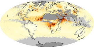
A visualization created with data from MODIS instruments aboard Terra
and Aqua shows the global distribution of
fires (above) and the distribution of aerosols (aerosol optical depth, below) from Jan 2005
- July 2013. This visualization can also be viewed as an animation.
 |
| Average monthly aerosol amounts around the world, July 2013 |
- You can view, download, and analyze data on active fires and aerosol optical depth from NASA Earth Observations (NEO):
- Active Fires (Data from 2000-August 2013)
- Aerosol Optical Depth (Data from 2005-August 2013)
No comments:
Post a Comment